Assessments Page

Search This Blog

About Me

My photo
I am a third year student studying unmanned aerial systems at Purdue University.

Wednesday, April 29, 2020

Potential Solutions to Integrating UAS into National Airspace

Introduction

Getting drones into controlled airspace has been a topic that has been swirling around the FAAs discussions ever since the past few years when flying has really picked up. Some of the greatest agencies in America and other countries have attempted to come up with solutions for maintaining safe flights while also allowing the freedom that flying allows. NASA has developed a potential UAS traffic management (UTM) system that has the potential to allow for safe tracking of UAS inside controlled airspace. The FAA has also developed test sites in order to test potential ideas. The Netherlands even has integrated UAS into their airspace!

NASA's UTM system

NASA has proposed two systems under the UTM system. One a portable version that is smaller and designed for the agricultural fields that use drones today to spray solutions onto their crops. This would solve a large issue for the agricultural side of UAS ops. The second design was for low altitude operations that are much more varied by nature. the benefit of this system though is that it is always monitoring and will be able to detect all ops within its range, whereas the Ag solution is more for small business and only detects when it's on and only for a small area. 

Testing Sites

These tests were initially ordered by Congress for the FAA to prove that they could successfully monitor UAS platforms while they were in controlled airspace. Initially, they found that many states were interested in testing, and about half of the US submitted their own proposal for them to be chosen as a site. If this didn't find anything in the testing it at least discovered how much of a demand there is for UAS platforms to be allowed into the national airspace and should encourage further testing.

Netherlands Airspace

For a long time, the Netherlands had shelved the idea that they could incorporate UAS into their current airspace. A study was developed in 2001 with the Delft University of Technology and the Netherlands Ministry of Defence where they have addressed many of the issues of having UAS platforms enter their airspace. They have currently elected to do so gradually and go through each phase step by step to ensure that both sides of the situation are covered and one side isn't limited unfairly.

Conclusion

By looking around and taking what works from many things and combining them together, sometimes you get something greater than the sum of its parts. As this problem is super complicated and raises a lot of issues the best thing that can happen as of now is to wait for solutions to be developed. As there already have been many of the major problems covered by various countries and programs around the world, it'll only be a matter of time before we can fully integrate UAS into national airspace

Potential Issues with UAS integration into national airspace

Introduction

When trying to add something into the already crowded airspace today provides a lot of potential challenges. Even something like a rocket launch causes flights to be rerouted just for that brief point that it must travel through controlled airspace. Integrating something like UAS provides its own unique challenges, size, flight characteristics, and safety all will impact the industry.

Size

Drones come in many shapes and sizes, Some only about 5 inches while others are as big as small aircraft. This provides its own challenge as most of the time the pilot is scanning the airspace that they are traveling through with there eyes. Seeing something that is 5 inches while traveling at close to 150 mph is next to impossible, and for a pilot, if you can't see something you can't avoid it. This provides challenges in spotting for something like a quad that wants to travel through controlled airspace. Developing ways to combat this is one of the first steps that are needed in order to integrate UAS into the national airspace.

Flight Characteristics

As a typical airliner takes off they fly something called point-to-point. This means that when they leave they leave the congested airspace to fly to another airport with congested airspace. As drones typically have a limited flight time they are more likely to stay close to an airport like a GA aircraft. This means that they are more likely to add to the congestion that the airport is already facing making jobs like air traffic controllers more difficult as they have to continuously route aircraft around the unmanned vehicle. 

Safety

A potential issue that affects drones is the risk of a total communications loss. This would impact the data coming from the drone and the data going to the drone. Data like position data coming from the drone telling both other aircraft and the pilot where the drone is is extremely dangerous. As stated previously drones are already not very large aircraft and not being able to know exactly where the aircraft is puts anything that is in the air around the aircraft at risk. Another point on this is the fact that even if the pilot could get video the controls wouldn't work in this case as well, making flying the aircraft impossible. This can be mitigated with proper fail-safes in place that will direct the drone on what to do if communications are lost. 

Conclusion

These three points are some of the most important points that must be considered when adapting the modern airspace to one that will allow for drone flights. Usually, the military is used as a stepping stone to help see integration practices but in this case, they aren't helpful. Military drones typically operate in a segregated airspace away from manned ops, and they even let drones fly over soldiers as the data that they can record from a battle is more likely to add to the success of the mission then provide issues.

Monday, April 27, 2020

UAS use durring a virus epidemic

Introduction

When the world is in a lockdown, limiting where the public may go and what they can do many people sit around bored with nothing to do. As something as simple as physical contact becomes something to spread fear its a struggle for some to get the things they need and in a timely manner. As many people have and use drones they can also be something used to just enjoy the lack of people around. As safety is the number one concern bystanders walking around a busy city would make it a very dangerous flight, something that a quarantine produces is a distinct lack of people out on what would be busy streets allowing for some creative drone footage that otherwise wouldn't have been able to be captured.

Deliveries

As mentioned earlier being locked inside all day every day does create some issues. As food supplies run out and simple necessities run out a quarantined citizen will be forced to head out into the infected world. A way to elevate this and minimize the spread of disease would be getting your products delivered, although this also has its own effects. The logistics of getting vehicles to homes with the supplies that are needed while also not being used to spread the infection can be challenging and many companies have sprung up attempting to do this. The benefit of using something like a drone is the ability to fly the supplies to people in need with 0 human interaction. This allows for a minimal chance of the disease to be spread while still allowing for the needs of citizens to be met. As many commercial drones are smaller with limited lifting capabilities, this has become more of a trend on social media to just deliver a note or roll of toilet paper and not real necessities but is definite proof of concept for what the future will hold.

Deserted City Footage

As everyone is locked in and forced to stay at home some of the most crowded places are finally empty. This is one of the biggest concerns when flying a drone as no one wants a drone to fall out of the sky onto someone. With this deserted appearance to the cities, it can create a surreal experience while still allowing the pilot to have a safe flight with minimal people below. 

Tracking infected and uninfected

As some cities got hit by COVID differently they all have used drones differently. The Chinese government had drones up with thermal imaging cameras in order to track people with elevated body temperature, a known symptom of COVID. Some US cities are using them in a slightly different way by attaching loudspeakers to the platforms and using them to shame people out breaking the quarantine.

Silly Tasks

As mentioned drones can also provide some enjoyment when hit with the quarantine boredom wave. People are using them to keep a safe distance but also socialize. Some attach notes and fly them to people on balconies while others used them to walk their dogs while not breaking quarantine. The possibilities to use drones to help with this quarantine boredom are only limited by the imagination of the pilot.

The History of UAS

Introduction

Unmanned aerial vehicles have come a long way. The first one a basic RC like aircraft that had simple controls and was used as target practice for gunners and pilots to practice shooting down targets during WW2 called the Kettering Bug. Many of these unmanned aircraft didn't even have sensors for data gathering until later. 

Post-WWII UAS

As the jet age loomed with the end of WWII the technologies had to adapt. The Ryan Firebee was similar to the Kettering Bug but was instead a jet-powered version. This was used in the same way as the Kettering Bug as target practice but was more accurate towards the current times simulating a Russian Mig or other jet aircraft. This was imperative for training soldiers as most of the military aircraft was turning towards jet power. 

As the cold war started to build there was a large concern with the number of subs that the USSR was able to produce. In order to combat this, the US military developed an unmanned helicopter with a TV camera that helped spot subs from the air. These being relatively cheap and easy to make they become a sort of disposable device to use when detecting subs.

As the cold drove on the U-2 spy plane was created for intelligence gathering over the soviet union. As the flights increased in frequency the USSR was furious and would try everything they could to shoot them down. Eventually, they succeeded and shot one down in 1960. This lead to the development of the Ryan model 136. A U-2 like aircraft that was unmanned and intended to be used for the same purpose, although it was canceled due to the SR-71.

Although the US had these new intelligence-gathering methods development on UAS platforms continued. A newer Firebee was designed and used in intelligence missions over Taiwan. This platform was called the FireFly and they flew 160 missions. Initially, the success rate of these aircraft was quite low and made it quite difficult to recover the data that they were gathering. This was due to a parachute and recovery system that didn't keep the vehicles intact and destroyed the data that they gathered because of this. As the wrinkles were ironed out the success rate increased and the missions continued.

Conclusion

UAS platforms of the present didn't just appear overnight. They had to be developed and tested extensively in order for them to function correctly. As with the creation of GPS, the military was the best group to do this testing as they had the budget and the expertise with developing cutting edge tools and devices to protect the US. As the technology moved to a more civilian area the building blocks that were learned with the Firebee, and FireFly. Without these aircraft unmanned systems as we know of today wouldn't exist or at least in the same way.

The C-Astral Bramore

Introduction

When it comes to stable platforms for aerial data gathering there are very few that come close to the C-Astral Bramore. The platform that we have at Purdue is the PPX variant. This particular wing has a downward-facing sensor bay that can house a multitude of different sensors that can help with data gathering. 

Features

Aircraft

The Bramore PPX is an auto-piloted UAS platform with limited manual capabilities. The Bramore's ability to gather data while also being able to fly for almost 3 hours makes the aircraft an invaluable asset for data gathering. The aircraft's onboard flight controller allows it to fly the programmed route without the need for human correction and the only occasion where one might have to interact with the drone is in an emergency. It is launched with a catapult that quickly accelerates it to its flight speed where the engine can catch it and fly the aircraft. It lands via a parachute which allows for very short landing zones (weather dependant) which can help land the aircraft in tight areas where other fixed wings would struggle.

Sensor

The sensor for the Bramore is very powerful, at 42.2 megapixels it allows the pilot to gather data almost to the centimeter level. The other option that we have available is the Altum Multispectral which "sees" in 5 bands, 2 of them outside of the human spectrum. This is very useful when it comes to data gathering as filtering according to the band type will allow you to see things that your eyes originally wouldn't have seen.

Ground Station

The ground station is where all of the programming for the Bramore's flight happens. It is as easy as drawing a box over the area and the computer will automatically plan a route to cover the area in the least amount of passes. As mentioned previously the manual controls are limited but this is because of the excellent ground station. Allowing the PIC to manage what the aircraft will do through failsafe if a dangerous situation occurs. There are a multitude of things that the aircraft has the ability to during a failsafe, it can loiter in the area, return to the home point or even just deploy the parachute if the situation is very dangerous.

Conclusion

The Bramore PPX is a very powerful high-end UAS platform that gives you what you pay for. With a price close to $80,000 you get a platform that can fly for about 3 hours and give you data that's so accurate you could practically take your measurements for a suit with the data.

Wednesday, April 22, 2020

Understanding Crew Resource Management

Introduction

Flying any aerial platform can require many tasks to both ensure the safety of the flight and ensure that the data is collected properly. As there can be many different tasks to perform it is also helpful to have multiple people around to help with those tasks. This comes to an important fact of "too many cooks in the kitchen" and when safety is the number one thing it is important to have set rules and boundaries for crew members to be able to successfully complete the flight without overstepping. This is why crew resource management (CRM) is so important.

What does CRM do?

CRM in its basic form is like a job description for all crew members so they know their jobs. This keeps members from overstepping and keeps everyone focused on their task so that all the resources of the flight are used in the best way possible.

Pilot-in-Command (PIC)

The first and most important job is the pilot in command. They are in charge of all aspects and what they say goes. That being said their most important job is the safe completion of the flight and they should never do or tell anyone to do something to compromise that fact. The PIC is the person who flys the aircraft much like a real pilot. Their job is to focus their energy on maintaining the flight and providing the opportunities needed for the sensor operator to do their job

Sensor Operator (SO)

The SO is the person who is second in command, almost like the co-pilot of the mission. Their job is to operate the sensor and gather the data required for the flight. Usually this involves conversations to the PIC and it is important to allow this communication to take place without interruptions such as bystanders talking over this conversation. The visual observer can be used to help regulate this and keeping bystanders quiet, this allows for the PIC and SO to solely focus on the flight.

Visual Observer (VO)

Although it's not the most important job, nor the one with the most authority, it is still an important task that is fulfilled by this person. The VO is in charge of watching both the drone and the operating area around the drone. They should alert the PIC if there is ever anything that enters the area that can impact the safety of the flight. They also are in charge of keeping any bystanders from impacting the flight in any way that would cause the flight to no longer to be safe. 

Safety Culture

In any aviation setting the number one thing that is stressed is safety. There is nothing that could ruin a fun day of flying like someone's hand getting caught by the prop or having a drone hit someone. This important fact is something that is woven into the very fabric of the society that aviation has formed. This sole reason is why the PIC's main job is maintaining the safety of the flight and keeping everyone safe. Just like how a pilot is responsible for going around a full-scale aircraft and inspecting it before a flight to ensure that it is airworthy the PIC must make sure that the drone that they are commanding is airworthy and doesn't have anything wrong with the aircraft. A common saying by the FAA is that every regulation that they have is written in someone's blood, or simply someone died and they made a rule to prevent a disaster similar. This gave birth to the safety culture that is around aviation and why safety is so important.

Conclusion

By using CRM a flight crew can manage the risks of a flight properly and can help keep the flight safe and able to be completed. CRM creates defined roles that will keep everyone in line and doing what they are supposed to be doing.

Using Drone Racing League to learn how to fly a Quad

Introduction

This blog is going to use a more casual atmosphere as it is my personal experience learning how to fly a drone and less on the informative side.

Simulators are something that full-scale pilots use to get practice on an aircraft. They might be learning the aircraft for the first time, trying to experience a specific failure or just practicing. Either way, they are not at an actual risk to the public, and they aren't risking a potentially very expensive fix if the plane does crash, obviously as it's digital. This same method is what caused me to turn to the Drone Racing Simulator (DRL) available on steam. This "game" allows someone to connect a controller to their computer and control a digital drone in the same way that one would in real life. 

Learning How a Quad Works

The Tutorials

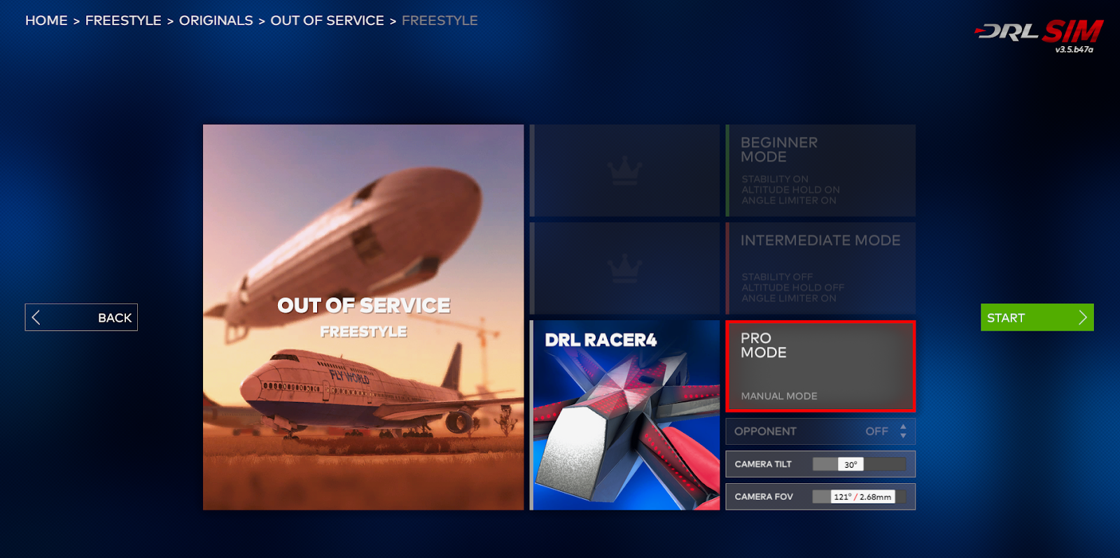
I have had minimum experience flying real quads when I came into the program. The most experience I have had is using a DJI Mavic Pro, a very stable and popular platform for many beginners and professionals alike because of how easy it is to fly. This was great to build a little confidence with an aircraft but I was still very nervous to fly it due to its extreme cost and lack of experience. So I jumped on DRL and started up a few tutorials in the basic flight mode. This made the quad behave exactly like a DJI Mavic Pro, locking the max tilt allowed and stabilizing itself for me when the controls were released, something the Mavic does too. As I build up about 5 hours of flight time on the basic controls I quickly wanted a little more of a challenge and switched to the intermediate mode and intermediate tutorials. This locked your maximum tilt but wouldn't self stabilize and after many crashes, I started to get the hang of it. Though I quickly realized that although it was called the intermediate mode I found the full acro mode easiest to fly and dodge obstacles because of the ability to move the drone 360 degrees in all directions, allowing for the force from the motors to point in any direction. Figure 1 is of the flight modes in DRL and their descriptions. At this point, I had put in about 10 hours total into the sim and had built up a bit of confidence.
Figure 1: The start menu before you go into a game with the modes listed

Rates

The next thing that I had to tackle was the rates, for a typical gamer this is like the sensitivity, allowing me to do flips very quickly or slowly based on the values. The starter values that DRL used were pretty slow and made learning the controls easy as a small bump wouldn't spin me in a random direction and confuse me more as I was trying to learn them. As I got more confident though I wanted the ability to do quick flips and cool maneuvers like you see on youtube. A friend ended up giving me values that he uses on his freestyle drone so that I would have a starting point to get used to and to feel what it would be like to fly one of his drones. These rates were much more sensitive and a simple full stick maneuver to one side would send the drone into countless flips. This was more to my liking and I quickly became accustomed to the rates after a few hours of freestyle flying. Figure 2 is of my current rates in DRL.

Figure 2: My personal rates

Cruising around

One of my favorite things in DRL was the size of the maps, having played quite a few video games in my time a typical map like in Call of Duty or similar game is usually pretty small. It was to my surprise that the maps in DRL were very big, some having a shipping center complete with cargo containers and a container ship, and a forest with a city nearby... all on the same map. This provides a fantastic experience being able to fly around between many different areas without being struck with a loading screen. It was about this time as I started building about 30 hours behind the sticks that I was getting pretty confident and starting to figure out the cool and complex aerobatic maneuvers that one will see when they type in "freestyle fpv" on youtube.

Racing

As I became more and more confident (around 40 hours) I started to race on the digital courses that they have available. As the sim is a racing simulator there is no shortage of tracks of varying difficulty and allowed me to become pretty good at racing. Although the process took a long time and I was constantly beaten by my friends who would also race alongside me in the lobby I slowly build more time up and soon started getting competitive to them at around 75 hours of flight time in the game.

Conclusion

It was around the 50-hour mark of flight time that my friend allowed me to try flying one of his real freestyle quads that he was going to be decommissioning soon, so he wasn't that big of a deal if I broke something, this defiantly made me a little less nervous, but I was still pretty nervous to go out there and fly something real around. I can happily report that in the 2 batteries that I flew that day I didn't crash once, although landing was "interesting" as that's something that you don't have to do in DRL and in all my hours of practice I didn't think of practicing that. 

I can confidently say that I am pretty decent with a quad now and I can say that it is all thanks to DRL and allowing me to build confidence behind the sticks without risking an actual drone.

Purdue Wildlife Area Flights with a Mavic 2 Pro

 Introduction Through Purdue's UAS program we were able to fly Mavic 2 Pros to do automated missions through Measure Ground Control to g...