Introduction
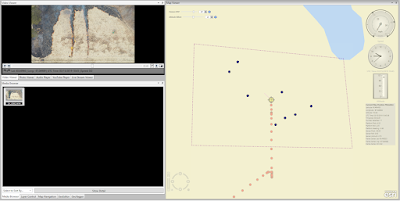
Using the software LineVision- Ultimate we tracked the latitude and longitude for certain points of interest along with the flight of a controlled burn. Using this software and assuming that the GPS was calibrated correctly, one can click on the video and see the exact latitude (lat.) and longitude (long.).
 |
| Figure 1, A screenshot of the LineVision software |
Going through and marking the points of interest along with the video so that the lat. and long. could be recorded. Recording them, they were placed into a table on Word to easily view the values quickly. The 4 items to track were some green trees, a Gator (similar to an ATV), an ATV and a blue truck. Also, there were two fire lines which the start and endpoint of each were plotted.
 |
| Figure 2, Table showing the points of interest and their respective Lat. / Long. |
In the example (Figure 1), the GPS information for the flight was corrupted and the GPS information was inaccurate, but the software still worked well enough to provide geotags for the locations. As this was more of a trial run to learn how to properly use the software the small issues were overlooked. Knowing this the data would have to be rerecorded and another flight would have been needed.
Conclusion
Due to the GPS error that was discovered with the data for this flight this data wouldn't be able to be used to conduct research and a new flight would be needed to rerecord the data. As this was used just to get used to the software it more showed how sensitive the software is to small errors and what those small errors can do to the data in this sensitive program


No comments:
Post a Comment